 6 Sep 2021
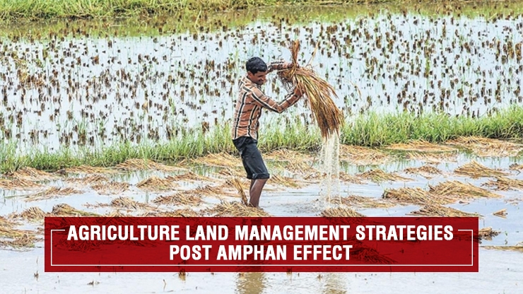
‘Amphan’ the most severe storm in the Bay of Bengal since the super cyclone of 1999, made landfall around 20 km east of Sagar island in the Sundarbans on 20th May, 2020 with a speed of 160 km per hour. Causing over 13 billion US$ of damage, ‘Amphan’ is the costliest cyclone ever recorded in the North Indian Ocean.
Damage caused by ‘Amphan’ in Sundarbans
About 1,200 sq. km. of the 4,263 sq. km. forests had been destroyed in Indian part of Sundarbans. The trees turned yellow to red in the Sundarbans after the cyclone due to salinity. Agriculture in north and south 24 parganas were affected severely by cyclone ‘Amphan’. Saline water entered into the crop fields causing not only destroying the crop but also causing the land not suitable for crop cultivation for coming couple of years. It is due to the increased levels of soluble salts in soil solution.
Previous Experience
West Bengal experienced cyclonic storm ‘Aila’ in May, 2009. In September 2009, a project namely “Strategies for sustainable management of degraded coastal land and water for enhancing livelihood security of farming communities” was implemented by National Agricultural Innovation Project, ICAR, funded by World Bank for the enhancement of the livelihood security and employment generation for the poor farming communities of the coastal region by increasing the productivity of degraded land and water resources Central Soil Salinity Research Institute, Regional Research Station (CSRI, RRS),Canning Town was the lead centre of the consortium and the partners were Ramkrishna Ashram Krishi Vigyan Kendra (RAKVK), Nimpith, Central Institute of Brackish water Aquaculture, Kakdwip Research Centre (CIBA, KRC), Kakdwip, Bidhan Chandra Krishi Viswavidyalaya (BCKV), Mohanpur and Central Agricultural Research Institute (CARI), Port Blair. Through this project about 349.58 ha of land in degraded areas of Sundarbans and Andaman & Nicobar Islands has been converted from mono-cropped to multi-cropped with combination of crop and fish cultivation through implementation of various land shaping techniques. (NAIP final report, Indian Council of Agricultural Research, 2013-14)
How to Manage Agricultural Land?
As saline water entered into the agricultural land, the first job is to reduce the soil salinity and to increase the availability of fresh water for irrigation. Being a part of this above mentioned project as senior research fellow, I will suggest the farmers to practice land shaping techniques like farm pond and paddy-cum-fish cultivation. Land shaping techniques, can reduce the salinity level of agricultural land by leaching down salts from soil and can provide harvested rain water for agriculture throughout the year.
Farm Pond:
About 20% of the land should be converted into farm pond of 3 m depth. The dug out soil is to be used to raise the land to form high land and medium land situation and also for making bunds at all four sides of the pond. High land and bund should be 1 m high from original low land. Pond should be 3 m deep with sloppy sides. Trench should be 1 m wide and 0.5 m deep. The pond will be used for rainwater harvesting of about 5000 m3ha-1 for irrigation and poly culture of fish.
Paddy-cum-Fish Cultivation: In this technique, trenches (3m top width × 1.5 m bottom width ×1.0 m depth) is to be dug around the periphery of the farm land leaving about 3.5m wide outer from boundary and the dugout soil was used for making dikes (about 1.5 m top width × 1.0 m height × 3m bottom width). A small ditch is to be dug out at one corner of the field for sheltering of fish when water will drain out in trenches. Dikes protected free flow of water from the field and trenches will be used for harvesting rain water. About 1400 m3 of rain water can be harvested in 1 ha of farm land under this land shaping technique. The dikes will be used for growing vegetables and / or green manuring crops/fruit crops/multi-purpose tree species round the year. Remaining portion of the farm land including the trenches was used for more profitable paddy + fish cultivation in Kharif. The farm land (non-trench and non-dike area) will be used for low water requiring crops during dry (Rabi/ Summer) season with the rain water harvested in trenches. Under this technique land embankment around the farm land was made with 4′ (1.2m) top width × 4′ (1.2 m) m height × 6′ (1.83m) bottom width.
Agronomic Practices needs to be Followed
- Maximum use of organic manures like compost, vermin-compost, farm yard manure etc.
- Use of salt tolerant crops and varieties.
- Practice of multiple cropping.
- Implementation of integrated farming system models.
Student’s Participation
Agriculture students can get the opportunity to participate in this programme through various projects funded by different national and international funding agencies.
Source: Final Report 2013-14, National Agricultural Innovation Project, Indian Council of Agricultural Research.
Share:


